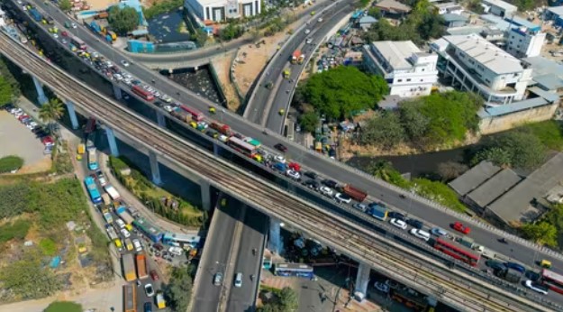
Once envisioned as a decongesting arterial corridor connecting major IT hubs, Bengaluru’s Outer Ring Road (ORR) has become one of the city’s most gridlocked stretches, a cautionary tale of how rapid commercial expansion without adequate infrastructure planning can hinder a city’s mobility and productivity.
The ORR was brought to a standstill on Tuesday evening after a bus broke down, causing a massive traffic jam. The breakdown led to gridlock stretching for several kilometres, severely impacting key routes in the city’s IT corridor. Commuters were left stranded, with some taking nearly two hours to cover just 12 km.
Urban experts say the transformation of ORR, from a planned bypass road to an overcrowded commercial corridor, highlights deeper flaws in Bengaluru’s urban planning model.
Commuters caught in a daily grind
For tech professionals working along the ORR, traffic congestion is not just an inconvenience; it is a daily ordeal that affects both health and productivity.
“I stay barely 3 kilometres from my office,” Chaitali Matkar, a tech professional who works on the ORR stretch near Bellandur, told HT.com. “A few years ago, it used to take me just 10–15 minutes to reach work. Now it takes 30 minutes even in the afternoon when traffic is lighter. On bad days, it has taken me over an hour and a half.”
Matkar describes the situation as “painful,” adding that poor road quality only worsens the commute. “The potholes are horrible. I’ve developed a backache, maybe even sciatica, because of these roads,” she said. “I live in a supposedly swanky residential gated society, but the moment I step out, hell begins.”
She is not alone. Commuters from areas such as HSR Layout and Electronic City report similar travel times despite living much farther away, underscoring how the ORR’s congestion has become a great equaliser; no matter where residents live, getting to work takes both time and a toll.
Once a bypass, now a bottleneck
Stretching over 60 km and connecting key employment clusters like Marathahalli, Bellandur, and Sarjapur Road, the ORR was originally designed to divert inter-city and heavy vehicular traffic away from the city’s core. However, over the past decade, the corridor has evolved into Bengaluru’s prime commercial belt, housing several office spaces.
According to a report by Cushman and Wakefield, the ORR submarket contributed 40% of gross leasing values for office spaces in Q3 2025, followed by Suburban East and Peripheral East with 26% and 16% shares, respectively. Overall, in Q3 2025, Bengaluru recorded a new office supply of nearly 3.6 million square feet (msf), representing a 21% quarterly growth. The Outer Ring Road dominated the quarterly supply, accounting for nearly 88%.
From January to September 2025, the ORR stretch experienced a net absorption of 3.8 million square feet of office space. An additional 16 million sq ft of office space is planned or under construction along the stretch, the report said.
Urban experts argue that the corridor’s congestion is a result of planning oversight. “The ORR was never intended to handle this density of office and residential development. The road’s design capacity was quickly breached when large-scale commercial projects were sanctioned without proportional upgrades to public transport or civic infrastructure,” environmentalist Sandeep Anirudhan said.
“If we look at the original ORR, it was part of the 1985 master plan and designed as a bypass, completely outside the city limits,” Anirudhan explained. “Everything on the other side of the ORR was designated as a green belt; no development was supposed to take place there.”
However, that vision changed drastically three decades later. “The 2015 Revised Master Plan (RMP) converted this entire green belt into a development zone, without introducing any new infrastructure to handle the additional load,” he said. “That’s when the real trouble began.”
Anirudhan said that the RMP 2031, which proposed multimodal transport systems and sustainable mobility solutions for emerging urban areas, “never saw the light of day,” as it was recalled in 2022. Earlier planning by the Bangalore Metropolitan Region Development Authority (BMRDA) had envisioned a Bus Rapid Transit System (BRTS) between ORR flyovers, a dedicated public transport corridor that would have eased congestion without disrupting mainstream traffic.
“Unfortunately, the idea was abandoned because it was seen as a competitor to the metro for ridership,” he said.
The result is evident; peak-hour travel speeds have dropped below 10 km/h, commute times between Bellandur (in south-east) and Mahadevapura (in east) stretch to over an hour.
Urban planners call for course correction
Experts say the ORR should serve as a wake-up call for upcoming growth corridors such as the Peripheral Ring Road (PRR) and the Satellite Town Ring Road (STRR). The key, they argue, lies in reimagining urban growth with a focus on mixed-use zoning, last-mile connectivity, and the emerging concept of a ‘15-minute city,’ where work, housing, education, and recreation are all within short reach.
Urban mobility expert Sathya Sankaran, also known as the Bicycle Mayor of Bengaluru, stated that the city’s ORR crisis is a direct consequence of fragmented urban planning and a lack of multimodal transportation options.
“Today, most people can not even cross the ORR to reach tech parks on either side,” Sankaran said. “We have created a system that forces everyone to get into vehicles because there is no efficient, integrated public transport that connects walking, cycling, buses, metro, and suburban rail.”
He emphasised that Bengaluru’s road infrastructure needs a fundamental rethink. “The available bandwidth on ORR needs to be re-aligned,” he said. “This stretch has major residential and commercial developments on both sides, yet there are hardly any parallel roads to divert traffic. Everything funnels into one corridor.”
Sankaran said Bengaluru must “go back to urban planning fundamentals,” stressing that road projects like ORR cannot be seen in isolation. “It is not just about building a road, but about the network it provides and the spatial planning around it,” he explained. “We did not prioritise modular, integrated public transport, so people in cars and buses now sit in the same traffic.”
He also highlighted the persistent issue of poor last-mile connectivity for metro and suburban rail users. “Until we fix that, we can not expect people to leave their vehicles behind,” he said. “If we keep developing residential gated communities along infrastructure corridors, we must also build a network of feeder roads to distribute traffic. Otherwise, everyone will continue to rely on one overburdened road, and that is exactly what is happening on ORR today.”
Land use, economic activity-based planning needed, say experts
Urban expert OP Agarwal, former CEO of the World Resources Institute (WRI) India, said that Bengaluru’s growth pattern leaves the city with little choice but to expand outward through additional ring roads and improved regional planning.
“There is really no escape from building more ring roads,” Agarwal said. “As cities expand, they need multiple concentric corridors; look at Beijing with its five ring roads, or Delhi, which continues to grow in the same pattern.”
He noted that Bengaluru’s rapid expansion has created intense pressure on its core, while nearby towns have not developed at a comparable scale. “Everyone is coming to Bengaluru, but the second-largest city in Karnataka is much smaller. We need to start thinking about developing satellite cities and improving their connectivity so people have viable alternatives,” he said.
Agarwal argued that Bengaluru must shift from fragmented, land-use-based planning to an integrated development approach that combines housing, jobs, and transportation. “Our planning has traditionally focused only on land use, not on economic activity and land use together,” he said. “What we need now are well-connected high-density pockets; mixed-use urban centres that are efficiently linked to one another. That’s how sustainable growth can happen.”


comments


Other categories
Recent Comments