Many of the world’s largest river deltas are quietly sinking faster than the oceans are rising.
Scientists are warning that a hidden form of land loss is accelerating across many of the world’s most important river deltas, with consequences that could rival or exceed the impacts of rising seas. According to a study published in Nature, large portions of these densely populated regions are sinking faster than ocean levels are increasing, placing hundreds of millions of people at growing risk of flooding.
Rather than being driven by climate change alone, the research points to a combination of human activities as the primary cause. Heavy groundwater extraction, the trapping of sediment upstream by dams and river engineering, and rapid urban expansion are collectively weakening delta landscapes and causing them to sink.
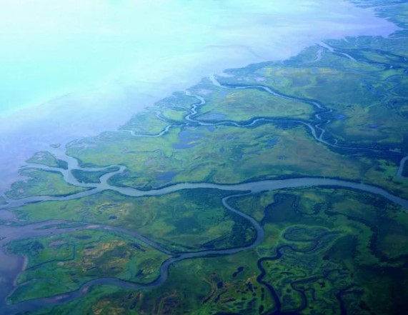
The international analysis represents the most detailed assessment of delta subsidence ever completed. Researchers examined elevation changes across 40 major river deltas worldwide, providing the first high-resolution, delta-wide view of how land levels are shifting over time. The project was overseen by Virginia Tech geoscientists Manoochehr Shirzaei and Susanna Werth and led by Leonard Ohenhen, a former Virginia Tech graduate student who is now an assistant professor at the University of California, Irvine.
The results reveal a widespread pattern of decline. Nearly every delta studied includes areas where the ground is sinking faster than the nearby sea levels are rising. In 18 of the 40 deltas, subsidence already surpasses local sea-level rise, intensifying flood risk for more than 236 million people in the near term. This means communities may face worsening flooding even without future increases in ocean levels.
Mapping Elevation Loss in Unprecedented Detail
To capture these changes, the team relied on advanced satellite radar observations capable of detecting subtle shifts in the Earth’s surface. By combining years of satellite data, the researchers produced detailed maps of elevation change across deltas on five continents, with each pixel representing an area of just 75 square meters. This level of detail allowed scientists to identify hotspots of rapid sinking that had previously gone undetected.
Some of the most affected deltas include major population and agricultural centers such as the Mekong, Nile, Chao Phraya, Ganges–Brahmaputra, Mississippi, and Yellow River systems. Many of these regions support tens of millions of residents and play a critical role in global food production, making continued land loss especially concerning.
“In many places, groundwater extraction, sediment starvation, and rapid urbanization are causing land to sink much faster than previously recognized,” Ohenhen said.
Human Drivers Behind a Growing Risk
Some regions are sinking at more than twice the current global rate of sea-level rise.
“Our results show that subsidence isn’t a distant future problem — it is happening now, at scales that exceed climate-driven sea-level rise in many deltas,” said Shirzaei, co-author and director of Virginia Tech’s Earth Observation and Innovation Lab.
Groundwater depletion emerged as the strongest overall predictor of delta sinking, though the dominant driver varies regionally.
“When groundwater is over-pumped or sediments fail to reach the coast, the land surface drops,” said Werth, who co-led the groundwater analysis. “These processes are directly linked to human decisions, which means the solutions also lie within our control.”


comments


Other categories
Recent Comments